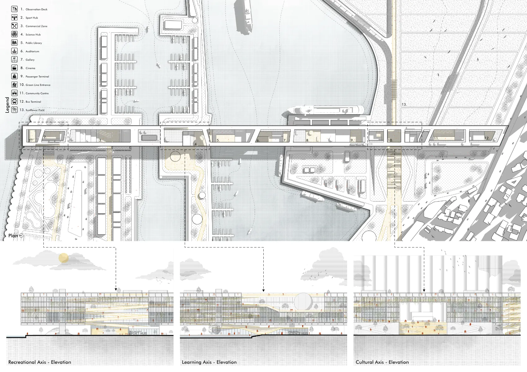
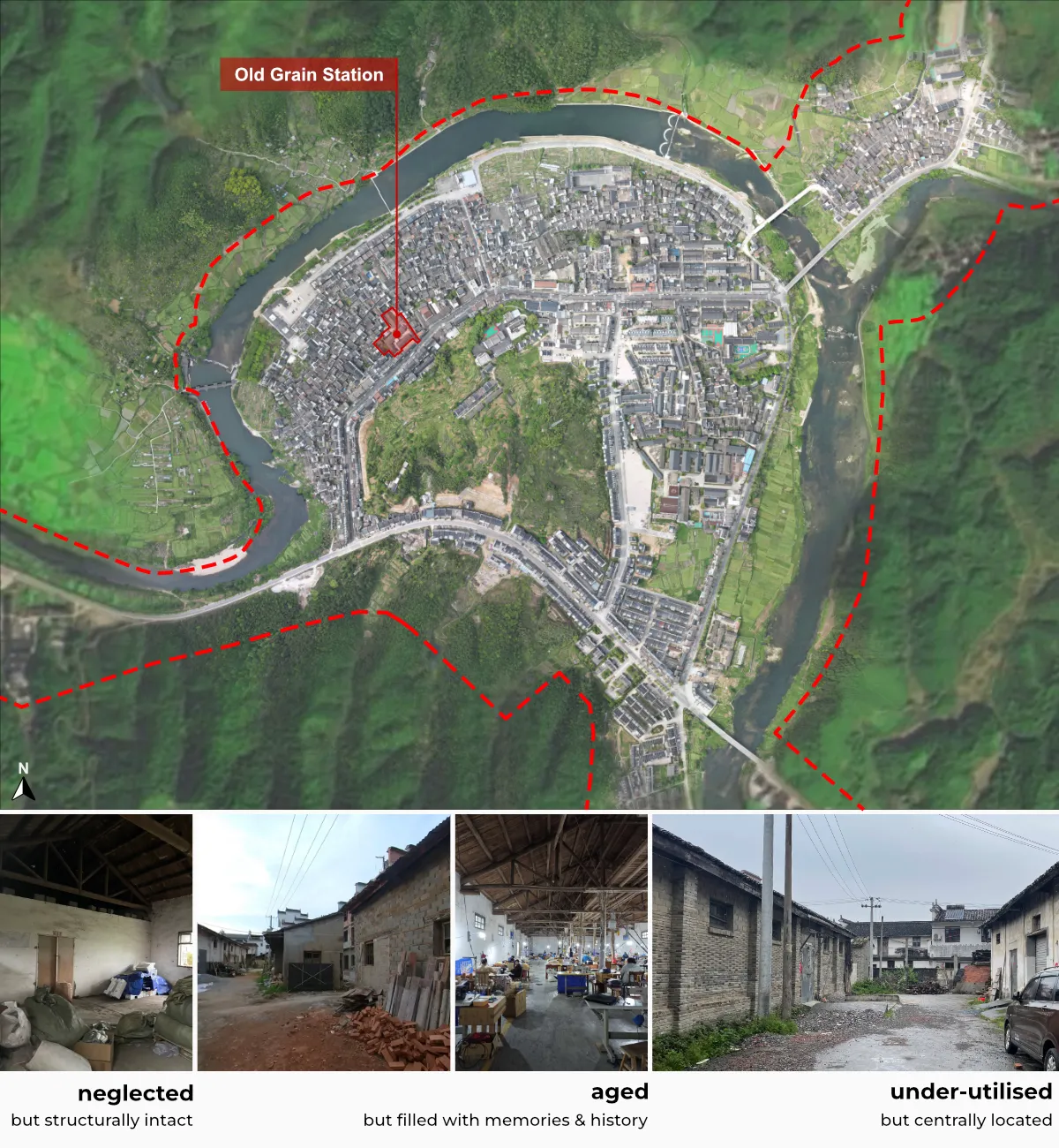
Situated in Qinghua Town, Wuyuan County, Jiangxi Province, the site was selected in collaboration with local authorities. Known for its scenic villages, field research revealed many neglected and underused spaces with overlooked potential within the region. Following an initial value assessment, the Old Grain Station was selected for its structural integrity, layered history, and strategic location, offering a distinct opportunity to transform it into a cultural space for both students and visitors.

Heritage has become increasingly present in our contemporary environment—an often deliberate mix of old and new that we have grown accustomed to. Yet the widespread popularity of adaptive reuse—especially involving industrial structures—has also contributed to the commodification of heritage, prompting the question:
Building on existing literature and case studies, a three-step framework was developed for the adaptive reuse of ordinary industrial heritage:
Dissecting the structure(s) and site into site layers and evaluating their heritage value.
Overall strategy to integrate the site back into its broader context.
Regeneration, adaptation, and extensions to the site, which showcase unique values and qualities of the original construction.
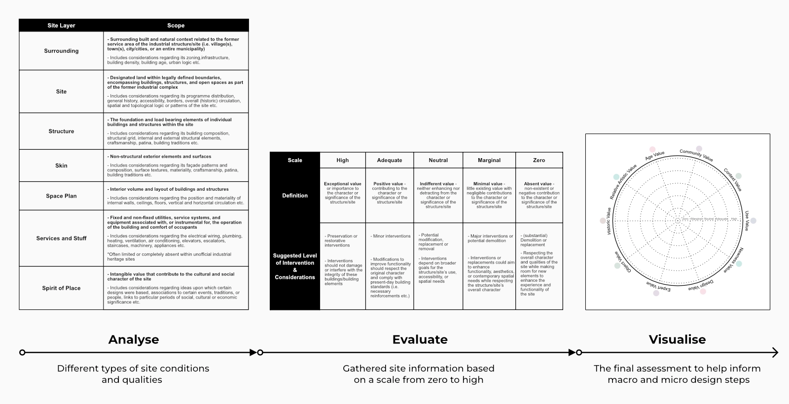
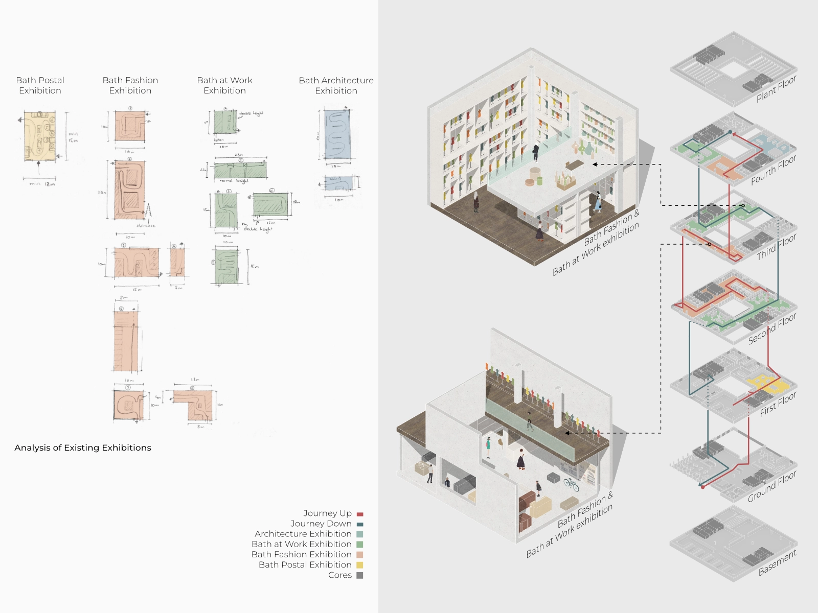
Recognising the complex character of industrial heritage, the site is dissected into seven site layers, evaluated and visualised through a ten-value radial chart.
Drawing from Brand’s spatial logic and value theories from Meurs and Riegl, this framework enables a holistic and context-sensitive understanding of place.
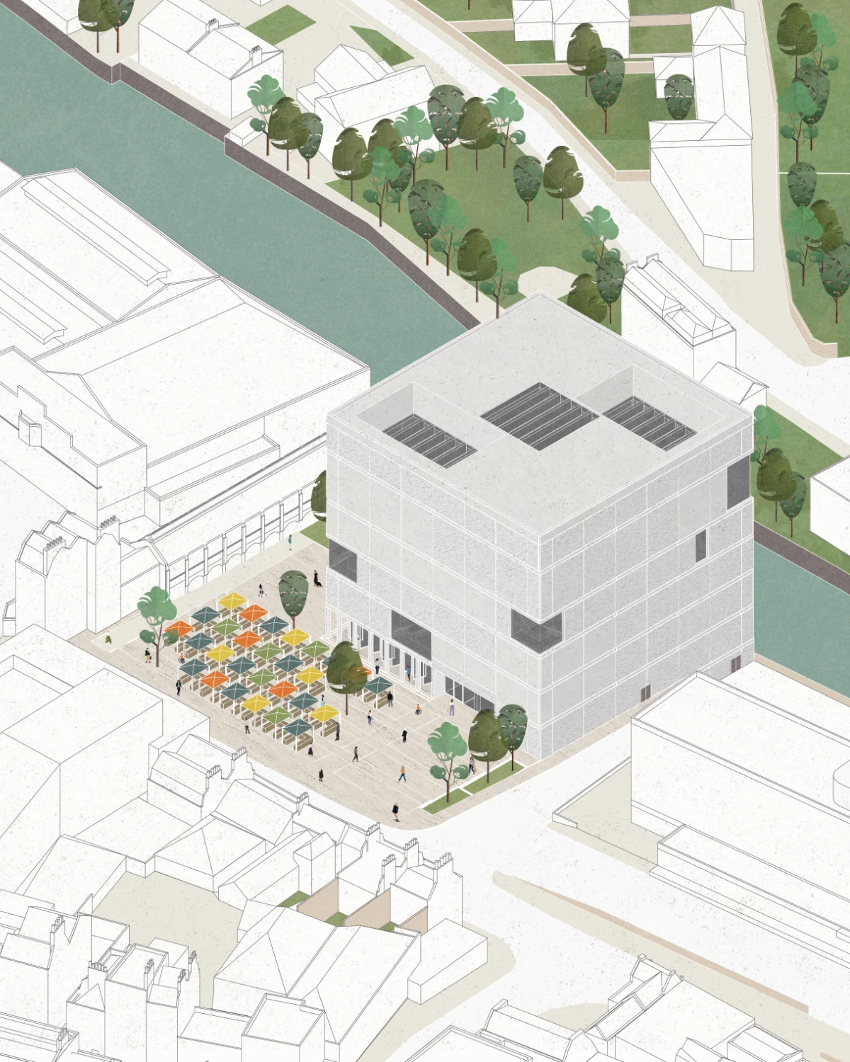
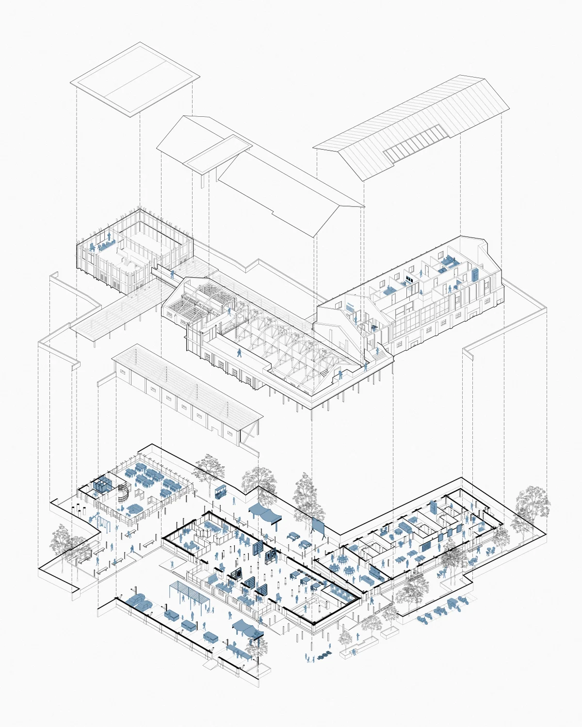
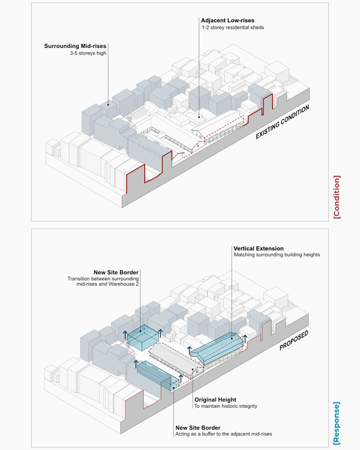
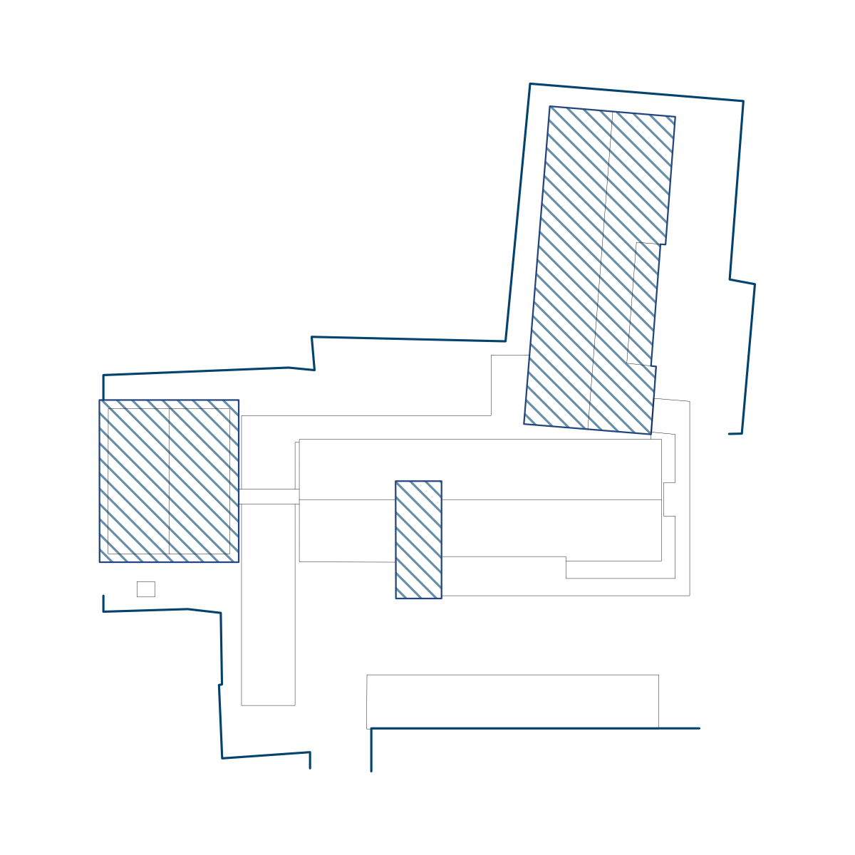
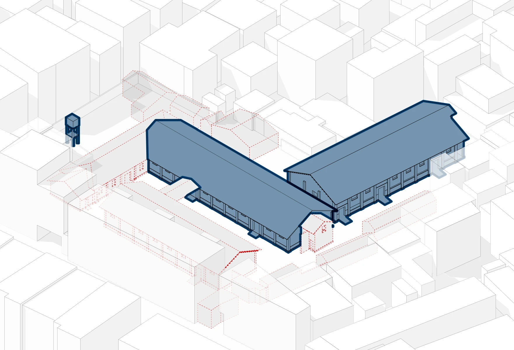
Tucked into the western centre of Qinghua Town, the Old Grain station spans nearly 4,000 m² with 4 main buildings and several ancillary structures. Built between the 1960s and 1980s, the site reflects a utilitarian and stripped-back approach, characterised by minimal detailing, straightforward spatial layouts, and fragmented outdoor areas.

Alongside a broader regional analysis, the subsequent value assessment identified 5 key values:
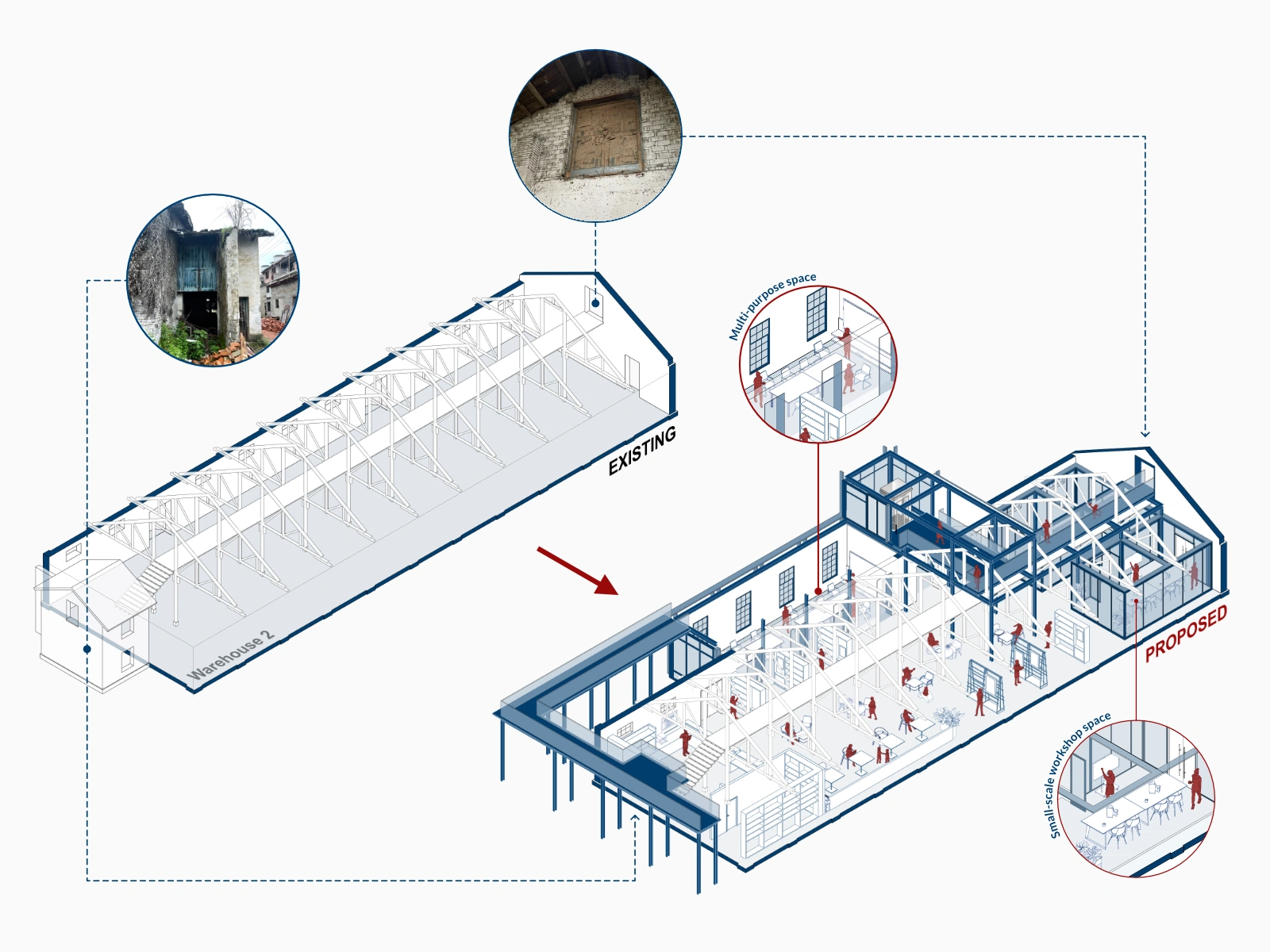
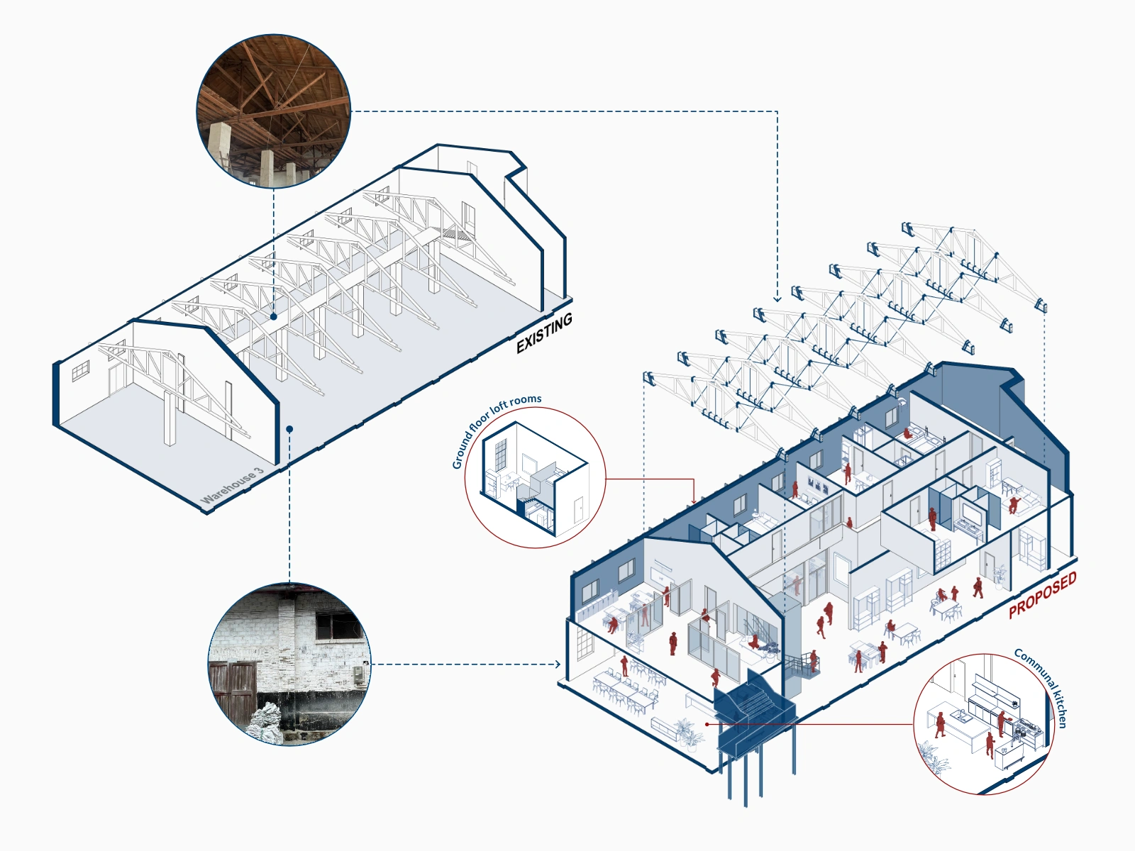
The assessment also led to the decision to retain two key buildings: Warehouse 2, for its distinctive architectural features; and Warehouse 3, for its functional layout and spatial relationship with Warehouse 2.
In contrast, Warehouse 1 and the office building are removed due to their structural limitations, low reuse potential, and spatial constraints.


Though formerly the county seat, Qinghua Town now faces social and economic disconnection from surrounding areas.
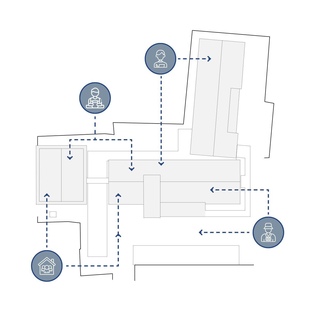
A preceding regional study identified 4 key user groups, shaping a programme centred on a research residency, a creative workshop, and a communal hall—designed to foster interaction and long-term engagement on site.
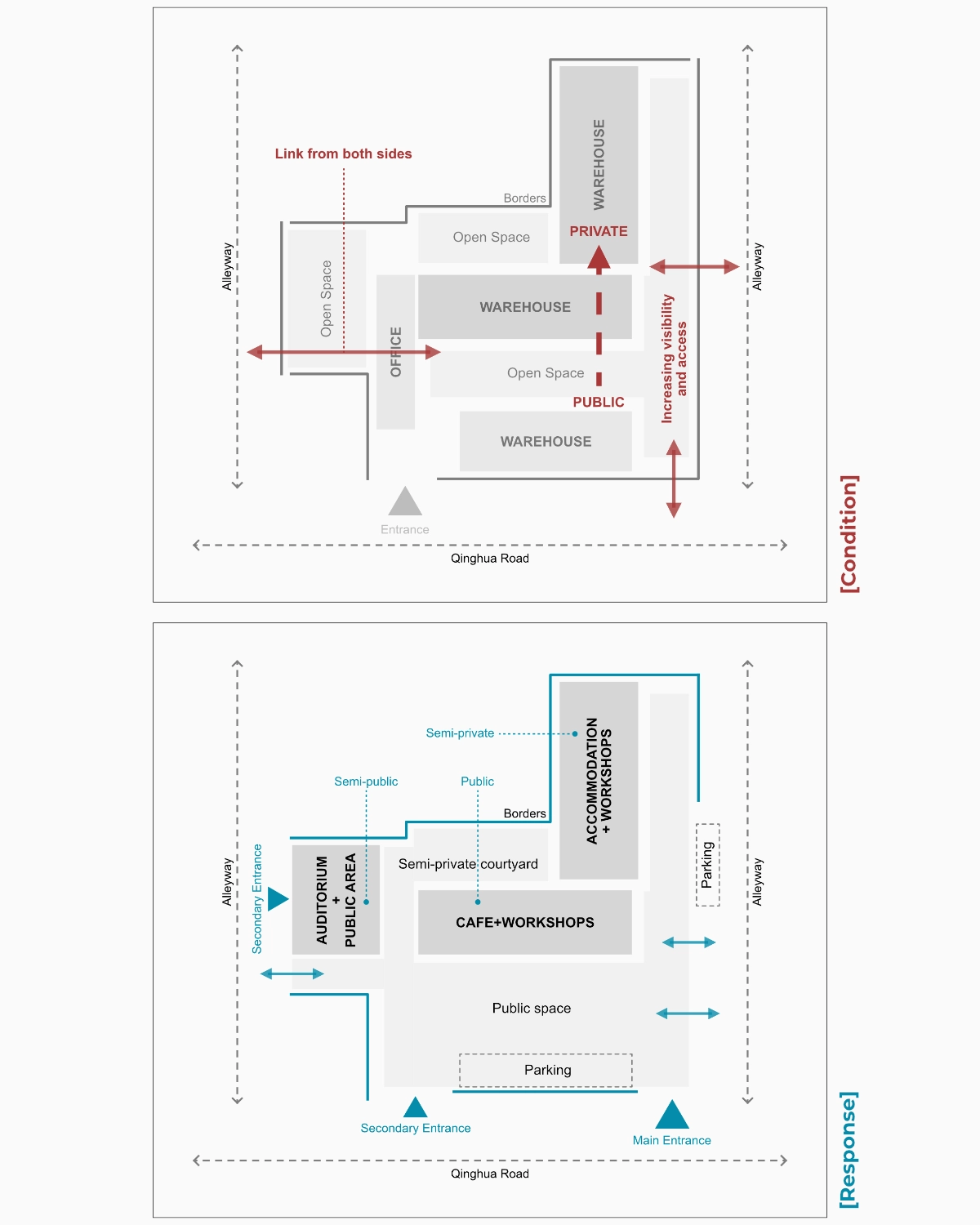
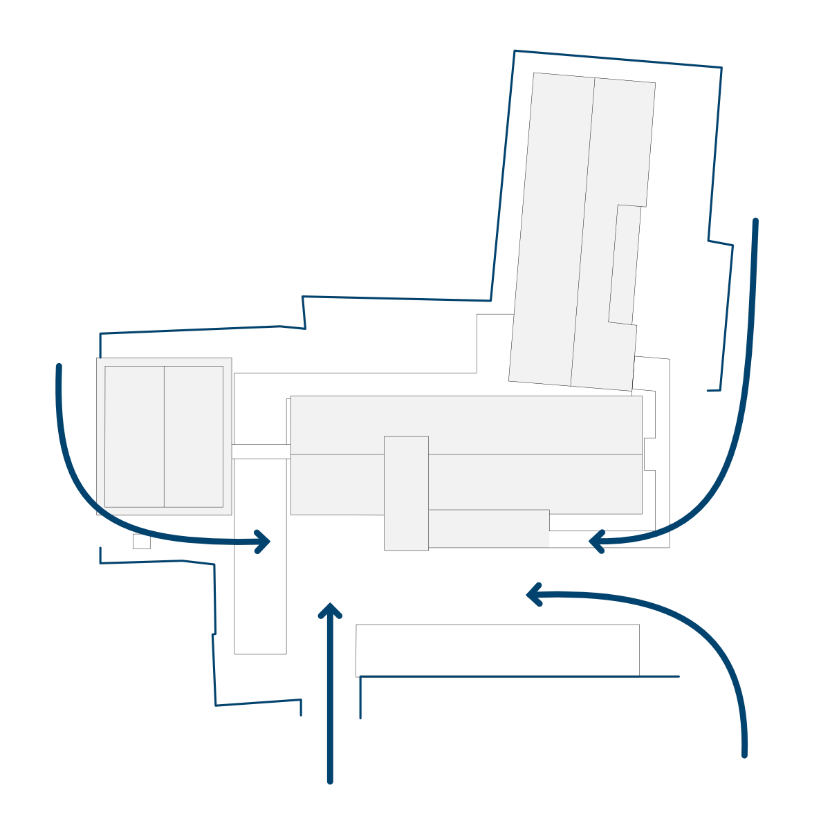

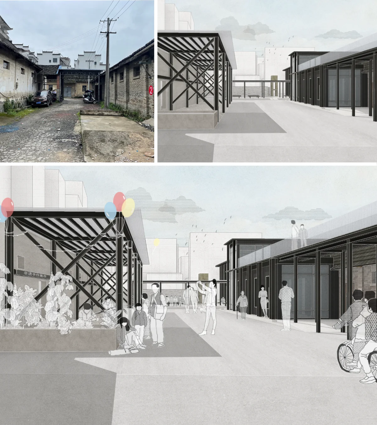
High walls and peripheral structures effectively isolated the site from its surroundings, despite its central location.
The revised layout opens key edges to adjacent streets, repositions the main entrance, and places public-facing programmes at the front, while private and larger communal spaces are set towards the rear and western edge to balance accessibility with privacy.


To enhance visibility and strengthen the site’s contextual presence, the massing strategy introduces a vertical extension on Warehouse 3, aligning it with adjacent buildings. A new structure on the western edge, along with targeted modifications to Warehouse 2, further supports a more seamless transition between the site and its urban context.


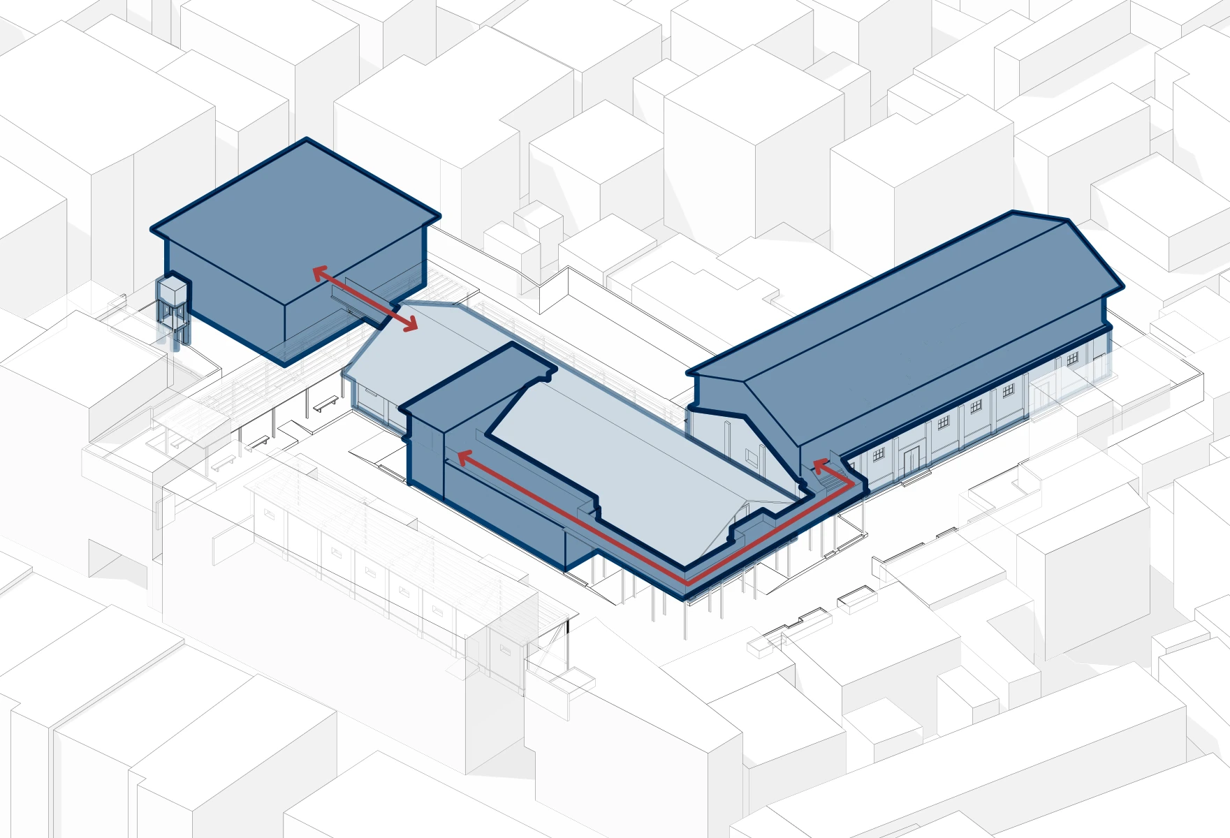
Building on the macro strategies, the micro interventions focus on accentuating, adapting and reconnecting the site through contemporary additions.
New workshop spaces are distributed across buildings, linked by an upper-level circulation route and a covered ground-level passage that replaces the former office. Additional parking provisions improve accessibility and respond to local planning gaps.

The conversion of Warehouse 2 into a 
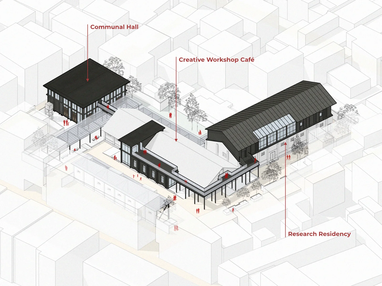
Creative Workshop Café
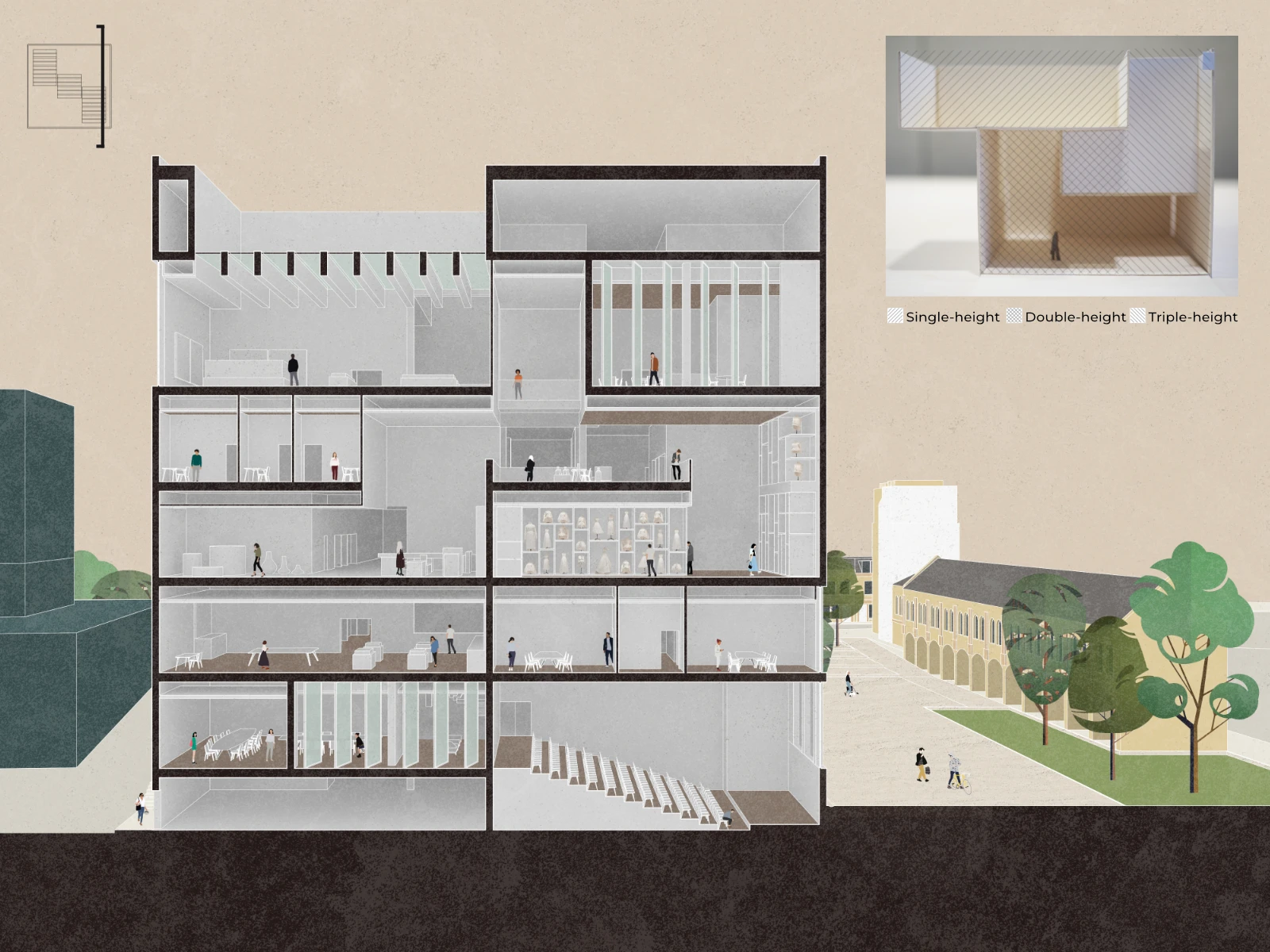
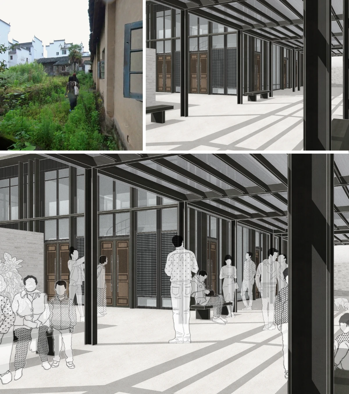
 involves subtle yet deliberate adaptations to the existing structure. Reflecting a traditional layout, the interior is symmetrically arranged, with two enclosed rooms to the west and an open reception and café bar to the east.

The central space is intentionally left open to preserve the building’s original spatial experience. A new access point connects the mezzanine to the Communal Hall via an existing west-side doorway, while the former eastern entrance is reinterpreted as a visual threshold.

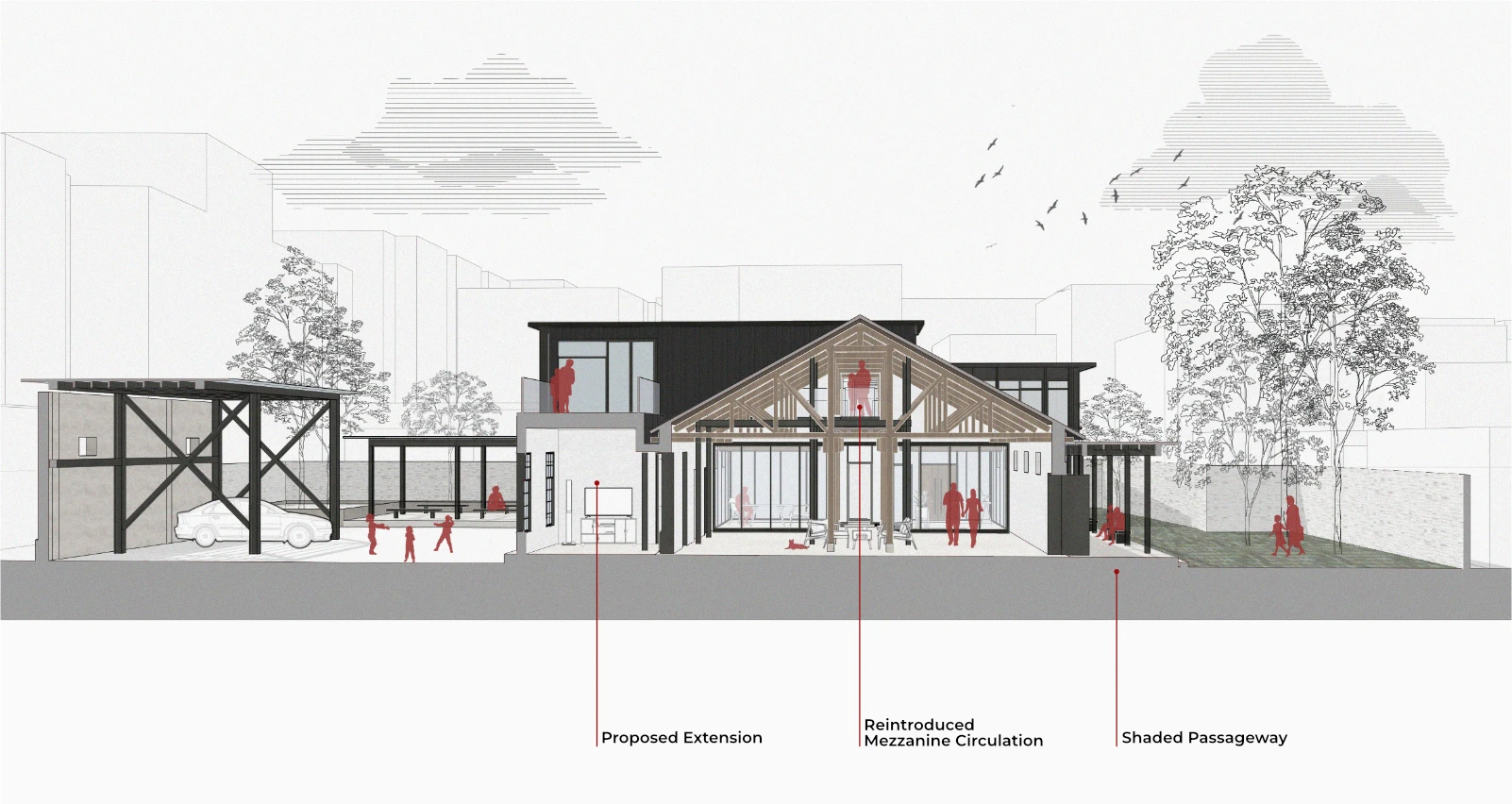
The Research Residency features a vertical extension to the former warehouse, providing living and working spaces for small to medium-sized research groups.
Existing masonry walls are largely retained, with a self-supporting steel frame structure inserted internally. The ground floor accommodates loft-style rooms and shared areas, while the upper level introduces larger bedrooms and multifunctional spaces. Here, the mezzanine is removed to maximise openness, with a central corridor reinstating the original axis of the building.
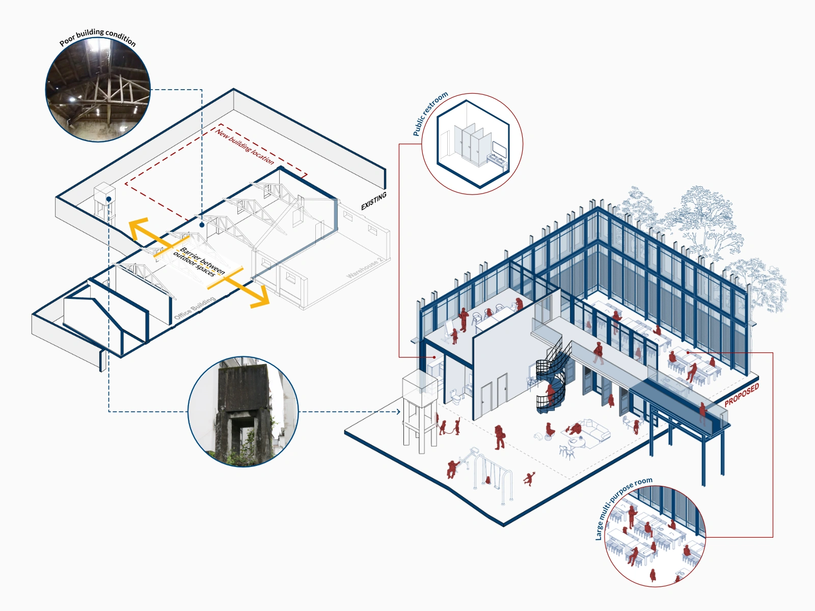
As the only entirely new structure, the Communal Hall accommodates larger spaces not feasible within the existing buildings. Positioned along a public alleyway, it also incorporates much-needed public restrooms—accessible from both the street and within the site to serve both visitors and the wider community.
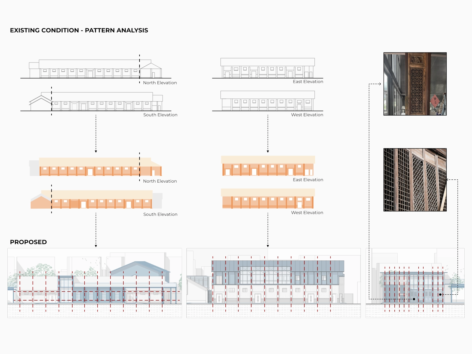
Externally, the new interventions maintain the repetitive, utilitarian rhythm of the existing façades. Situated between the site and traditional Hui-style surroundings, the Communal Hall introduces subtle deviations—patterned panels, reused traditional door leaves, and vertical emphasis—to bridge traditional and industrial expressions.

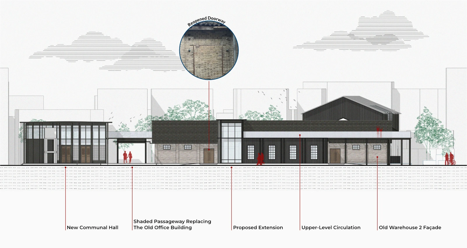
Reopening the previously bricked-up doorway restores the symmetry of Warehouse 2, allowing the new extension to seamlessly continue the façade’s rhythm through vertical metal fins and enlarged windows that maximise natural light.
While aligned in material palette, the Communal Hall deliberately adopts a lighter expression to accentuate the solidity of the original constructions.
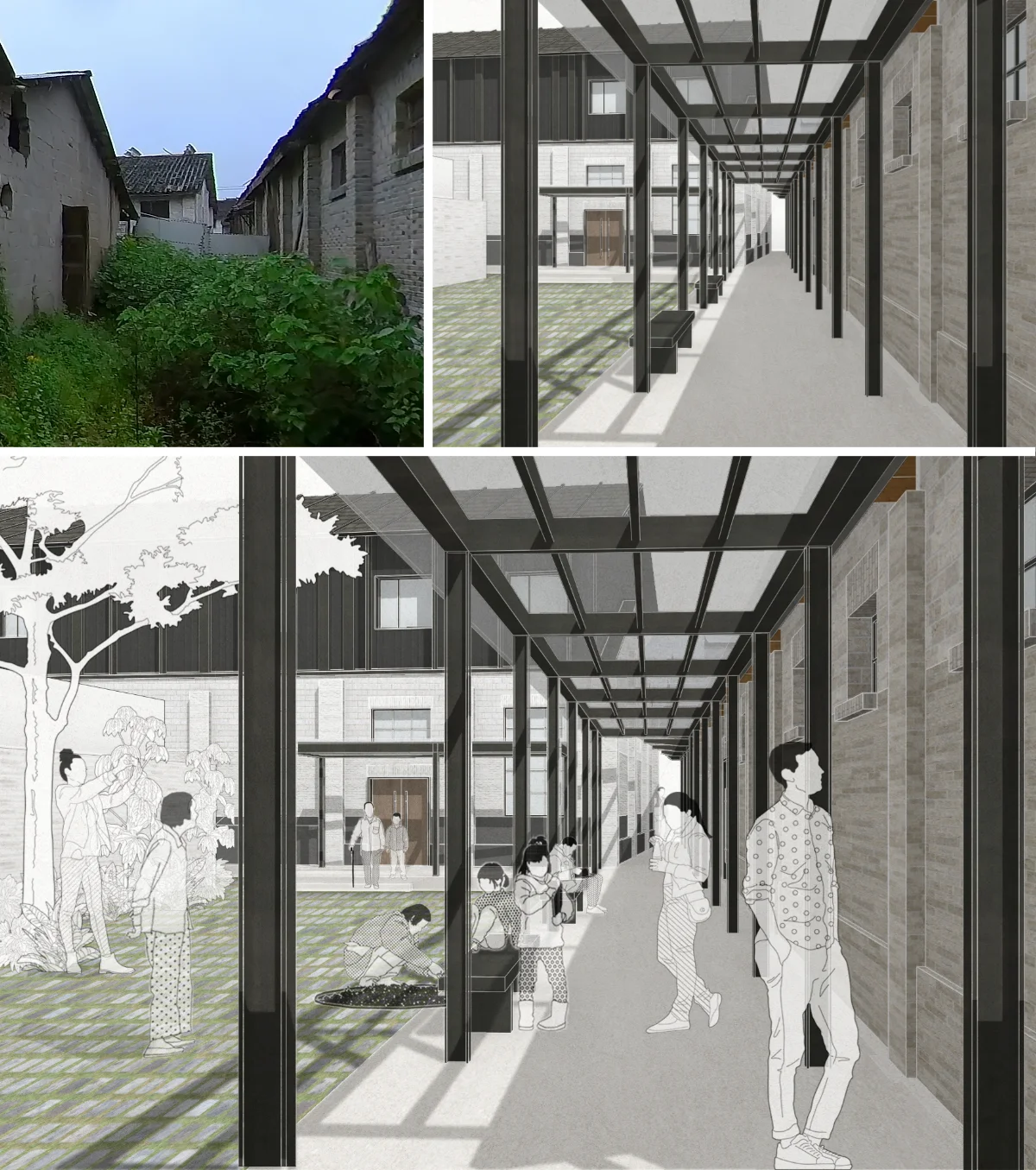
Rooted in the site’s history, the open spaces reinforce its social and public character. With the removal of the old office building and the opening of site boundaries, previously fragmented external areas merge into a continuous public space defined by shifting thresholds—from a front plaza to a shaded passageway and an intimate rear courtyard.
Connected to the interior through existing and new access points, these spaces support flexible uses including education, culture, and recreation.

*Note: Design development and visual output were a shared effort:
final renderings were produced by my teammate; diagrams and linedrawings were developed by me
In response to the August 2020 explosion in Beirut, an international student competition invited participants to redefine the city’s port under the F.D.B.O.T model (Finance, Design, Build, Operate, Transfer). The project brief emphasised the integration of commercial functions with cultural, civic, and commemorative spaces—aiming to restore economic relevance while reconnecting the site with Beirut’s social and urban fabric.

Given the sensitive context of the Beirut port explosion, site analysis became a crucial starting point for this project. Unable to visit in person, we relied on online maps, street views and other digital content to explore the area and obtain a sense of place. While the broader site analysis was carried out within our larger studio group, our team focused specifically on the city’s sociocultural context—delving into local habits, patterns of public life, and urban gaps, while mapping key historical and recreational zones.
Through this process, we identified the Green Line and the Coastline as two major urban threads converging at the port, revealing an opportunity to reconnect Beirut’s collective memory with its social fabric.

Our design process was iterative and research-driven, moving between sketches, discussions, and conceptual testing. From the start, we focused on the potential connection between the Green Line and the Coastline, exploring ideas of a greenbelt that would weave through the port site. This gradually evolved into a spatial framework cantered around a linear “Elevated Hub,” acting as a platform for community activity and connecting the historic and recreational layers of the city.

Understanding the site as a post-industrial brownfield, we incorporated its transitional nature into the proposal by allowing large parts of the port to recover through phytoremediation. We revisited earlier mappings and identified four key urban axes surrounding the site, aligning them with our hub to create distinct programmatic entry points that anchored the design within the city’s wider fabric.

The final design envisions a bold elevated public hub, connecting four urban axes of the city and bridging across the existing urban fabric from the northern coastline towards the Green Line –an intervention designed to create a new urban culture, inspiring wider regeneration and synthesis on an urban and social level.
For many years, the Beirut port represented more of a barrier than a connection between the city’s communities and its coast. The reconstruction of the port area opens up the opportunity for a pivotal civic gesture that will both catalyse the area and fill the void of active public spaces in the city.

Consisting of a series of (semi) open and multi-levelled courtyard platforms, the mixed-use public hub creates a rich spatial experience that inspires spontaneous moments and interactions between interior and exterior spaces; contained within a singular rectilinear form. Diverse programmes aim to attract both locals and tourists, becoming a starting point for dialogue between different social groups.
Central to the scheme is the permeability of the structure and versatility of space, enabling the freedom to adapt to the public’s needs. While proposing tentative programmes, the architecture does not impose a strict functional narrative on the users, but instead remains polyvalent by providing a framework that allows the programme to evolve with the city and its inhabitants.

While culturally and morphologically diverse, the compromised mobility network and inward-focused developments of the city have exacerbated the disconnection between the different communities and neighbourhoods in Beirut.
Converging towards the port site, The Beirut Lines becomes the connective element between the active coastline and historic Green Line, interwoven into the existing network of organised spaces in-between. By elevating the structure, The Beirut Lines liberates the ground plane, allowing the brownfield site to recover through phytoremediation using a sea of sunflowers, and creating better connectivity between the city and its seafront.

The revised port zone is located at the east end of the plot, while the brownfield remediation site opens up different possibilities for the area. We imagine a public recreational landscape at the central seafront, framed by an urban expansion zone which enables various cultural and commercial uses to promote greater social integration and economic viability.
In addition to the pragmatic purpose of the brownfield remediation site, it encapsulates the resilience and strength of Beirut and its people. The memory of the blast and its effects can be observed in two dimensions: the void and the ruins. The remains of the Silos structure (the ruins) are preserved, with wire mesh frames tracing the missing pieces, and stand amidst the sunflower field (the void) as a beacon of hope. Passing through the elevated public hub, users are taken on a journey, following the gradual recovery process of the site. The Beirut Lines extends the historic Green Line into the remains of the cardinal Silos structure, linking the memories of the city.

This project followed a self-developed brief investigating present-day challenges within the World Heritage City of Bath. Situated in a place that cannot help but reminisce over its rich history, the scheme aims to capture the unique experience of Bath—providing a piece of civic architecture that belongs to the city.

The project began with precedent studies examining architectural forms of expression—such as cladding composition, orientation, and spatial qualities of exhibition and civic architecture—to understand how these buildings respond to their surroundings. These observations, alongside spatial explorations of programme organisation and connectivity, informed the articulation of space, form and the project’s relationship with its urban context.

The design process began with modular volumes, tested in various configurations around fixed cores to frame moments of movement and pause. To integrate the exhibitions with the surrounding cityscape, an upward circulation route was introduced, culminating in a rooftop terrace. Early explorations with staircases and volumetric extrusions within the atrium created visual interest but resulted in convoluted circulation and structural challenges.
Relocating the staircases to the building’s edges clarified the relationship between circulation and display, resulting in a refined spatial narrative. This double-helix movement was demonstrated in the final crit using an LED model, where red and blue lights represented ascending and descending paths.

To foster a sense of belonging, the design prioritised a strong relationship between the building, the street, and the wider urban fabric.
Positioning the museum closer to the river creates a generous public space that reflects Bath’s urban character while accommodating the weekly artisan markets in the area. The descending approach to the entrance mirrors the experience of arriving in the city from the surrounding hills.

The integration of four existing collections prompted a critical analysis of their spatial layouts, visitor flows, and display methods—questioning established approaches and exploring opportunities for reinterpretation.
The proposed design echoes Bath’s undulating topography, guiding visitors through a sequence of varied spaces that ascend and descend across multiple exhibition levels, enriched by gentle slopes and contrasting volumes.

Given the diverse nature of the collections, the spatial study focused on both the sequencing of displays and the specific spatial requirements of each exhibition.
Intersecting volumes of varying heights established layered relationships between spaces. The North–South section captures this spatial experience, mirroring the shifting views of Bath’s terrain and allowing visitors to engage with the exhibitions as part of a collective cultural narrative.

While Bath’s architecture largely relies on a consistent use of Bath stone, subtle variations in texture and finish bring character to the city’s built fabric. This nuanced material expression formed the foundation for the museum’s façade design.
Inspired by the uniformity of Georgian Architecture, the building envelope adopts an object-like form, unifying the exhibitions within a singular volume. Shifts in texture suggest spatial variation, with smooth finishes marking double-height or sloping rooms. The entrance intentionally disrupts the façade’s rhythm to signal the point of arrival.
Internally, while exhibition spaces are inward-facing, the circulation routes frame curated views of Bath, blurring the boundary between the interior and the city.

Tectonic details played a key role in reinforcing the museum’s material language and its relationship to context. Along the façade edges, overlapping precast concrete panels alternate in direction, adding sculptural depth and visual rhythm.
Generous glazing around the café opens the building to the public space, forming an inviting threshold at street level. The placement and spacing of concrete columns subtly echo the rhythm of surrounding colonnades, integrating the building into the surrounding architectural fabric.

Structurally, museum is supported by a concrete frame structure, creating flexible floor space while simultaneously leaving room for future alterations and allowing the building to evolve with the city and its inhabitants.

Light-sensitive exhibitions are shielded from direct sunlight, while naturally lit spaces are reserved for less sensitive collections, educational areas, and administrative functions. A mechanical ventilation system ensures visitor comfort and maintains stable conditions for temperature-sensitive displays. Additionally, a rainwater harvesting system collects and filters runoff in an underground retention tank, supplying grey water back into the building.